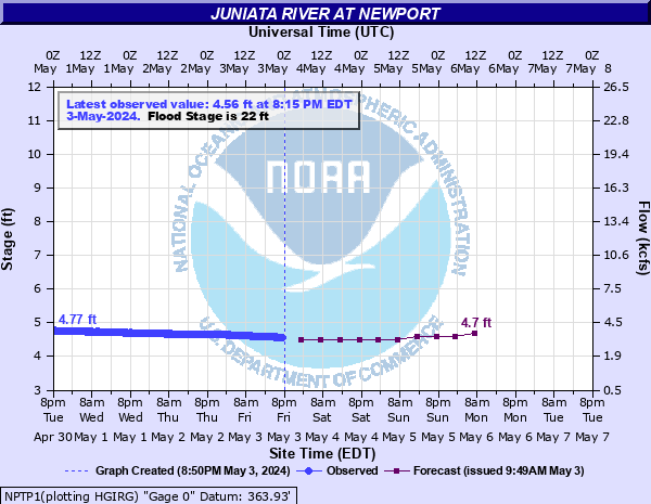
Juniata River at Newport
Critical Stages
17' - Action
22' - Flood
25' - Moderate
30' - Major
Latest Observation
Updated: 9:15 AM EST 12/14/25
Status: No Flooding
Stage: 3.55 ft
Flow: 1.05 kcfs
Forecast
| Time | Stage (ft) | Flow (kcfs) |
|---|---|---|
| 1 PM 12/14 | 3.5 | 0.981 |
| 7 PM 12/14 | 3.5 | 0.981 |
| 1 AM 12/15 | 3.5 | 0.981 |
| 7 AM 12/15 | 3.5 | 0.981 |
| 1 PM 12/15 | 3.5 | 0.981 |
| 7 PM 12/15 | 3.5 | 0.981 |
| 1 AM 12/16 | 3.5 | 0.981 |
| 7 AM 12/16 | 3.5 | 0.981 |
| 1 PM 12/16 | 3.5 | 0.981 |
| 7 PM 12/16 | 3.5 | 0.981 |
| 1 AM 12/17 | 3.5 | 0.981 |
| 7 AM 12/17 | 3.5 | 0.981 |
| Time | Stage (ft) | Flow (kcfs) |
|---|---|---|
| 10:15 AM 12/14 | 3.53 | 1.02 |
| 10:00 AM 12/14 | 3.53 | 1.02 |
| 9:45 AM 12/14 | 3.54 | 1.04 |
| 9:30 AM 12/14 | 3.54 | 1.04 |
| 9:15 AM 12/14 | 3.55 | 1.05 |
| 9:00 AM 12/14 | 3.55 | 1.05 |
| 8:45 AM 12/14 | 3.56 | 1.07 |
| 8:30 AM 12/14 | 3.56 | 1.07 |
| 8:15 AM 12/14 | 3.56 | 1.07 |
| 8:00 AM 12/14 | 3.56 | 1.07 |
| 7:45 AM 12/14 | 3.57 | 1.08 |
| 7:30 AM 12/14 | 3.57 | 1.08 |
| 7:15 AM 12/14 | 3.57 | 1.08 |
| 7:00 AM 12/14 | 3.58 | 1.1 |
| 6:45 AM 12/14 | 3.58 | 1.1 |
| 6:30 AM 12/14 | 3.58 | 1.1 |
| 6:15 AM 12/14 | 3.58 | 1.1 |
| 6:00 AM 12/14 | 3.58 | 1.1 |
| 5:45 AM 12/14 | 3.59 | 1.11 |
| 5:30 AM 12/14 | 3.59 | 1.11 |
| 5:15 AM 12/14 | 3.59 | 1.11 |
| 5:00 AM 12/14 | 3.59 | 1.11 |
| 4:45 AM 12/14 | 3.59 | 1.11 |
| 4:30 AM 12/14 | 3.59 | 1.11 |
| 4:15 AM 12/14 | 3.6 | 1.13 |
| 4:00 AM 12/14 | 3.59 | 1.11 |
| 3:45 AM 12/14 | 3.6 | 1.13 |
| 3:30 AM 12/14 | 3.6 | 1.13 |
| 3:15 AM 12/14 | 3.6 | 1.13 |
| 3:00 AM 12/14 | 3.6 | 1.13 |
36' -
Record flooding is expected on the Juniata in the vicinity of Newport. Water levels are expected to exceed the levels experienced in the March of 1936 flood and with Hurricane Agnes in 1972.
34' -
Almost the entire business district and a large residential area are affected by high water. Approximately 50 percent of Newport is inundated.
32' -
Considerable flooding occurs on both banks. Most streets in the business district are closed. Numerous homes and businesses are affected.
30' -
The right, or south bank overflows. Streets begin to be affected by high water. Most of the business district and a large residential area are affected.
28' -
Considerable flooding occurs along the left, or north bank and in low lying areas near tributary streams on the right, or south bank.
26' -
High water affects low lying areas on the left, or north bank and near tributaries on the right or south bank. Several homes are affected.
25' -
The left, or north bank overflows. The first floor of several homes in low lying areas will flood.
24' -
Considerable basement flooding occurs due to backwater from tributary streams.
22' -
Backwater from tributary streams affects basements of a number of homes.
| Date | Stage (ft) |
|---|---|
| Jun 1, 1889 | 35.9 |
| Mar 19, 1936 | 34.24 |
| Jun 23, 1972 | 33.97 |
| Nov 26, 1950 | 25.36 |
| Mar 1, 1902 | 25.3 |
| Jan 20, 1996 | 24.700000762939 |
| Mar 6, 1964 | 24.61 |
| Mar 6, 1936 | 24.51 |
| Apr 27, 1937 | 24.44 |
| Sep 19, 2004 | 23.58 |
| Feb 15, 1984 | 23.21 |
| Nov 29, 1993 | 17.73 |
| Mar 26, 1994 | 17.67 |
| Sep 26, 1975 | 17.15 |
| Mar 29, 1993 | 16.24 |
Data provided by the National Weather Service.